")
")
Namibia

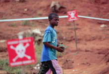
MgM helped in 1999 to demine the Ruacana power line in the north of Namibia.
The MgM areas of operation are color coded: The area of the Rucana power lines are marked in blue. The Owambo land is marked in orange, the Caprivi strip is marked in red
Overview Namibia operation
Namibia
Geography
Namibia is a vast and mostly semi-arid country situated on the south-western tip of Africa, bordered by Angola in the north, Zambia and Zimbabwe in the extreme north-east, Botswana in the east and South Africa in the south.
Despite its size of 825 000 square kilometers, it only has about 1.8 million inhabitants, two-thirds of whom live along the fertile river basins adjoining Cunene, Kavango and Zambezi Rivers in the north-western, central northern and north-eastern areas respectively.
The rest of the country is largely savannah, with the entire west taken up by the oldest desert in the world, the Namib Desert; the south-east forms part of the Kalahari Desert. Roughly two-thirds of the country is considered as arid or desert.
A brief history
Namibia was first settled by the Khoi and San people millennia ago; about 500 years ago, the first Nguni and Bantu peoples starting moving in, first occupying the more fertile northern areas and later also the central plateau.
In 1883, the first German settlers arrived in Luderitz; the subsequent discovery of diamonds some 20 years later sped up the colonization and the colonial forces soon found themselves at war with the first the indigenous Herero and then the Nama people (1904-1907). Despite this brief period, the German presence imparted a distinctive German flavor to the country that remains today still.
With the outbreak of World War I, the then-Union of South Africa invaded what was then German South West Africa, which was then turned into a C-Mandate by the League of Nations. Under apartheid South Africa (1948-1994), the new occupiers settled the area and resisted efforts by the international community to grant independence to Namibia.
Armed conflict
In 1963, the South West Africa People’s Organization (SWAPO) launched their armed struggle against the forces of apartheid, first from Zambia and after 1975, from Angola. This was a guerilla war largely conducted from within southern Angola; the apartheid authorities responded by turning the entire north into a war zone that stretched from the Atlantic to the Caprivi Strip in the east.
Landmines started appearing in the war zone from the early 1960s as part of SWAPO’s guerilla warfare; the apartheid armies (SADF and SWATF) responded by laying mines around all their bases and vital installations in the area.
The country’s main hydro-electric station, situated on the Cunene River at Ruacana, was also heavily fortified; fearing sabotage of the power line to Windhoek, the SADF mined the areas around each of the 409 pylons between Ruacana and Werda Gate.
Need for Private Funding
There is an immediate need for Private Funding to drive forward an initiative MgM needs to push forward in Malanje Province. MgM has the equipment, resources and expertise to make this project a success, the demining huge piles of mine infested earth that present a definite threat to local communities, we just require money to start this emergency project.
Info - The global mine problem

An overview and current numbers on the land mine issue
Interview - Haller Da Silva
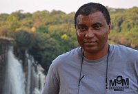
An interview with MgM Angola national manager Haller Da Silva talking about his job for People against landmines: Interview with Haller